KML or KMZ to GPX
Drew the route in Google My Maps or Google Earth? Export it and drop it here. This is the most faithful conversion of the three: a KML already holds the line you drew, so there are no roads to rebuild and nothing to guess.
Your file never leaves your browser. The conversion runs on this page, in JavaScript: nothing is uploaded, nothing is stored, and we never see the file. Open your browser's network panel while you convert - there is no request to look at.
These tools run in your browser, so they need JavaScript. With JavaScript off there is nothing we can do here - but the same conversions run server-side on motogpx.org, which works without it.
Your GPX
Used for the track name inside the GPX and for the downloaded file name.
How to export from Google My Maps
- Open your map at mymaps.google.com.
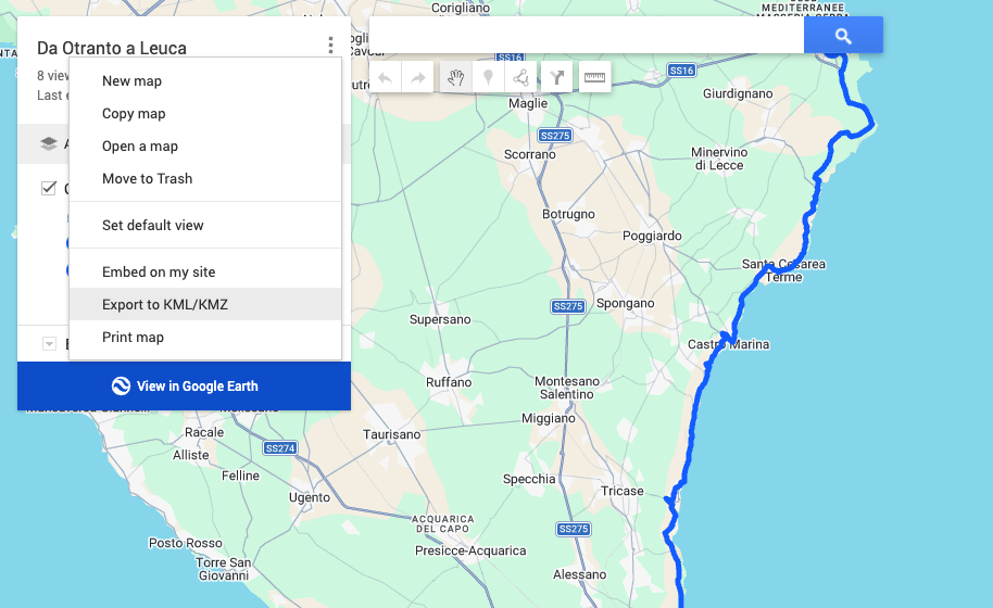
- Click the three-dot menu next to the map title, then "Export to KML/KMZ".
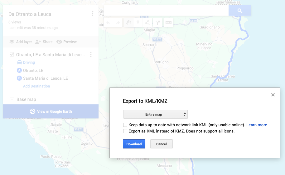
- Tick "Keep data up to date" off, choose the whole map, and download.
- Drop the downloaded file here.
Questions
My map has several layers. What happens?
Pieces that touch end to end are treated as one route and joined - that is how a "directions" layer exports, one piece per leg. Genuinely separate lines are not joined, because that would invent a straight leg between two unrelated routes; the longest is kept and the page lists what was left out.
What about my pins and markers?
Pins are not part of the track, so they are left out of the line. A GPX track and a set of places are two different things, and mixing them would give your sat-nav a route that jumps between points of interest.
Does KMZ work too?
Yes. A KMZ is just a zipped KML, and your browser unzips it here on the page. On a browser more than a few years old the unzipping may not be available - in that case rename the .kmz to .zip, extract doc.kml and drop that in instead.
Why is this conversion "the most faithful"?
Because nothing is reconstructed. A Google Maps link gives us stops and leaves the roads to a routing engine; a KML contains the actual drawn geometry. What you drew is what you get.
The other tools
You have the GPX and you want the route on your phone. Get a ready-made Google Maps link, plus a KML that keeps every single point for Google My Maps.
in your browserGoogle MapsGPXYou planned the route on Google Maps and your sat-nav wants a GPX. The roads between your stops are rebuilt point by point, and you can correct them on the map.
needs our serverGPXKMLYou want the track in Google My Maps or Google Earth, with every point kept - not the eleven stops a Maps link can hold.
in your browserGPX / KML / KMZYou just want to see what is in the file: the track on a map, its distance, its points, and the time it took.
in your browser